3.6
Free
Arm Map Explorer
Locate and view any object on the planet using interactive maps
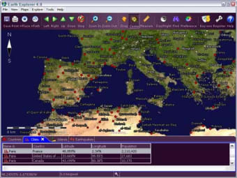
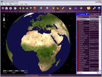
Motherplanet Earth Explorer integrates high-resolution satellite imagery (1km resolution) with kinds of map layers such as political boundaries, coastlines, rivers, lake and island boundaries, 267 countries and regions, 40000+ ranked cities, 15000+ islands, and 1700+ noteworthy historical earthquakes since 1980 into a fantastic 3D earth globe.
You can specify what kinds of map layers to be shown, rotate the globe, click right mouse button and pull/push to zoom in/out the current map view, measure distance between any two points on the map, etc.
Key features:
Investigate the world of earthquakes in 3D
Explore the world in 3D
Explore Geography with Marble on Windows
Trial version
Windows
Other platforms (1)Windows XP
English
21K
10.23 MB
Have you tried Earth Explorer? Be the first to leave your opinion!
Add reviewFree
Locate and view any object on the planet using interactive maps
Free
Explore the world in 3D
Free
Create maps for travel films and lectures
Free
See the current moon phase anytime, anywhere

Free
Synchronize your computer clock over the Net
Investigate the world of earthquakes in 3D
Explore the world in 3D
Explore Geography with Marble on Windows
An information system designed to analyze and manage geographic information
A trial version Science & education program for Windows
Explore Geography with StatPlanet
Free Application to Access the GPS Data of a Mobile Device
Make up cards for what you want to memorize
Explore and discover the planet
A Free Science & education program for Windows
Investigate the world of earthquakes in 3D
Comprehensive Mapping Tool for Education
GeoEdu: An Educational Geography Tool
Creepy: A Free Educational Geography Tool
Locate and view any object on the planet using interactive maps
GPSconverter converts Waypoints, Tracks, and Routes from/to any file format for GPS receiver or mapping program.
A free app for Windows, by INRIX Inc..
Explore the world in 3D
A free app for Windows, by Data Arc.
A Free (GPL) Science & education program for Windows